Labor Day. This is when I love Miami. Just as Fall starts to set in just about everywhere else, with the leaves browning, animals and people stocking up for the winter, here it is the opposite. Bring in the first tentative indications of the subsiding of the sweltering of the Summer. Bring in the first trickles of snowbirds, returning from the four corners of the world (but mainly Canada) to which they’ve retreated from that sweltering. And bring in the peak of the hurricane season, when God fires the low-pressure storms like bowling balls, one right after another. I’m not even remotely close to kidding, either:
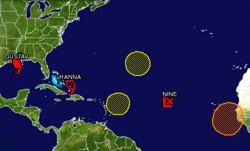
To the left we have Gustav, Category 2 Full Blown Hurricane, currently hitting New Orleans and the rest of Louisiana, maximum sustained winds of 110 mph, and as we speak keeping me in terror of turning on the TV. (But seriously, can you imagine? — an entire city built under sea level, so that in times like these, 100% of them there populace has to evacuate, (and despite the much-publicized few holdouts, I believe most of them in fact have), and the city is presumably empty but for (futile?) looting-prevention squads of National Guard, waiting to be hammered like a fat kid at best, or at worst — what? — wiped off the face of the Earth?)
Next up we have Tropical Storm Hanna, maximum sustained winds of 60 mph, currently doing its business to the Bahamas, and strengthening as it moves towards Florida, the cone of danger veering wildly from the north to the south from advisory to advisory (the NHC really should archive its advisories and maps, so we can see just how well their computer models have done over the years), but with an excellent chance of ruining next weekend for me.
The next low-pressure system appears to have split up into two areas of crappy weather. They may continue to move westward, but they’ve forfeited any chance of blooming into cyclones. Not much, but what heavy weather they bring will be seen as a resting point between volleys.
. . . hot on the heels of which is currently Tropical Depression 9, maximum sustained winds 35 mph, and so probably by the time you read this to be proclaimed Tropical Storm Ike. Doesn’t look like much, but by next weekend it’ll have likely covered two thirds of the distance between its present location and Miami. Are you starting to see my point?
And of course we have the seemingly big orange blob, officially “a strong tropical wave,” where the butterflies are currently doing their fluttering between the coast of Africa and the Cape Verde islands. Orange indicating here “medium potential for tropical cyclone formation,” natch. It too is moving towards us, 15 to 20 miles per hour. OK, so I turned on the TV for a bit. Something about a little bit of good news, and but “some of the levies may already have been breached.” Spawning tornadoes.
But wait, I was talking about why I like this time of the year. The danger I guess is part of it. We don’t have those browning leaves down here to remind us, yadda yadda, of the circle of life, the Forces at Work, on this planet. We have these volatile storms that always look like they’re just bearing down on you, and sometimes they do bear. There is a level of danger, but it’s what’s called a tolerable level. There are warnings, and there are possible preparations and evacuations, and the damage is usually the kind that you can put just dollar signs in front of. My heart goes out to the city of New Orleans. Hope you’re safe. But this, as they say, is part of it.
(Sorry about the high-school-newspaperesque fever of my writing here. I’m just getting back into it, ok?)
Gustav blew its load early. Hanna will hit South Carolina… and it’s good to have you posting again. You should submit Alesh as possible name for next year’s season!
I know, right?
Meanwhile, according to the latest, we’re still in the cone of possibilities.